Cases / Defence & Dual-Use · 2026
EW Activity Layer: GNSS Interference as a Map Layer in a C2 Platform
A telemetry-only layer for a C2 platform that turns GNSS health, EKF and link data from the fleet into time-fading jamming and spoofing zones. Won the Intelic Award; verified in simulation.
Context
GNSS jamming and spoofing are a known threat to unmanned systems. In a fleet view, the symptoms show up vehicle by vehicle: a position drifts, a link degrades, a vehicle drops to a fallback mode. Each vehicle already reports the symptoms (GNSS health, EKF divergence, link quality), but I did not see them combined into a map layer that shows where the interference probably is and what the operator decided about it.
Challenge 01 at the hackathon, "Extending Nexus", asked for an extension to Intelic's C2 platform for unmanned vehicles. I chose this gap: show the operator a separate EW layer built only from data the fleet already sends.
My role
I worked alone. I framed the operational problem, set the product constraints (no extra sensors, no new hardware, explainable output), designed the confidence model, wrote the engine and the SITL test injector, packaged it as a Nexus extension, built an interactive prototype of the behaviour I wanted, wrote up the platform feedback, and presented the result.
What I built
A separate map layer from existing telemetry. The engine ingests per-vehicle GNSS health, EKF divergence and link quality, and accumulates evidence on a 250 m grid.
Confidence, not a binary alarm. Each cell carries a confidence value that fades with time (evidence half-life 7 minutes), and healthy readings reduce a cell's weight. One vehicle can contribute at most 0.5 to a cell, so a single faulty receiver cannot create a zone on its own. A zone is confirmed only at confidence 0.5 or higher and with two or more vehicles reporting.
A record of the operator's decision. The operator can ignore a zone or mark it for replan, and the decision is stored with the zone. The extension never commands a vehicle: it only records the decision, and the operator makes the new plan in Nexus. That gives a trail of what the operator knew and chose.
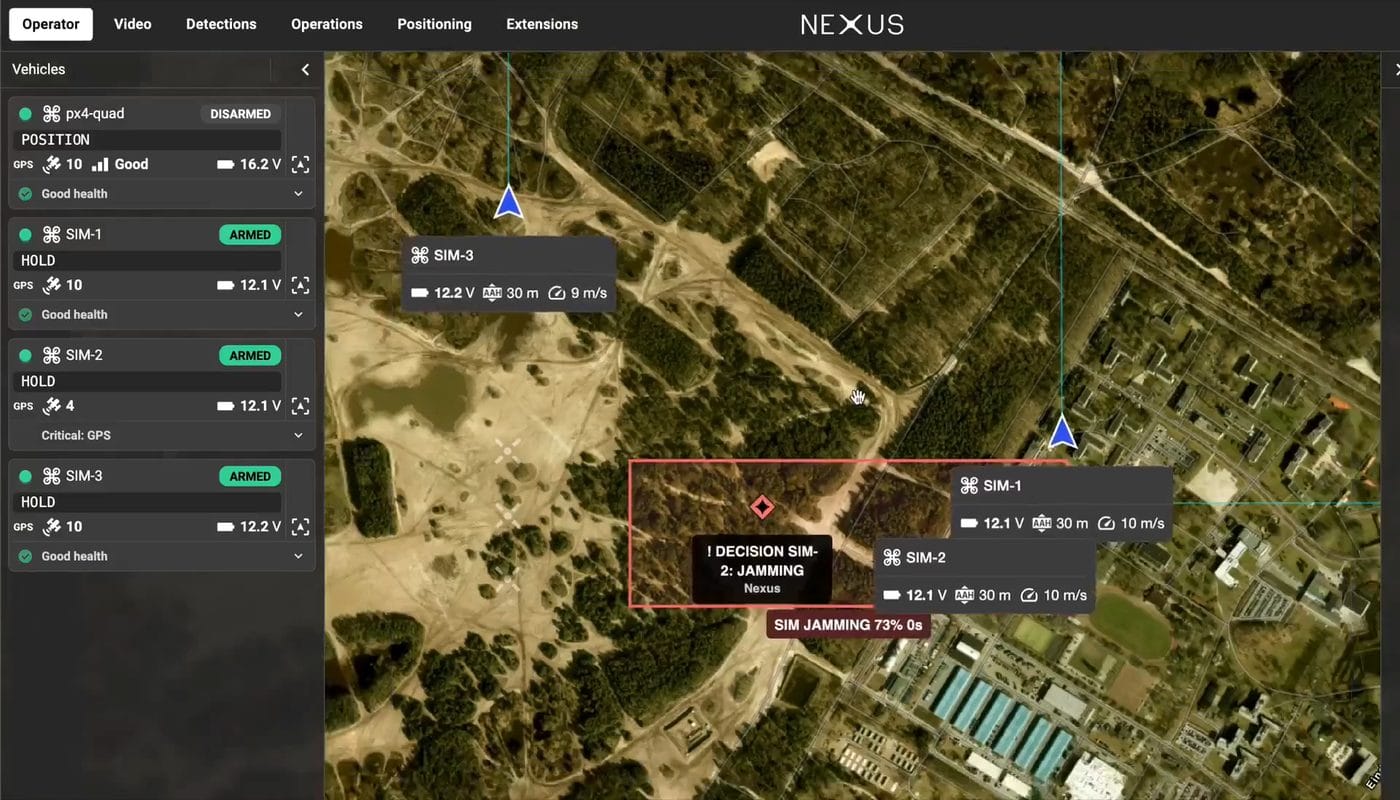
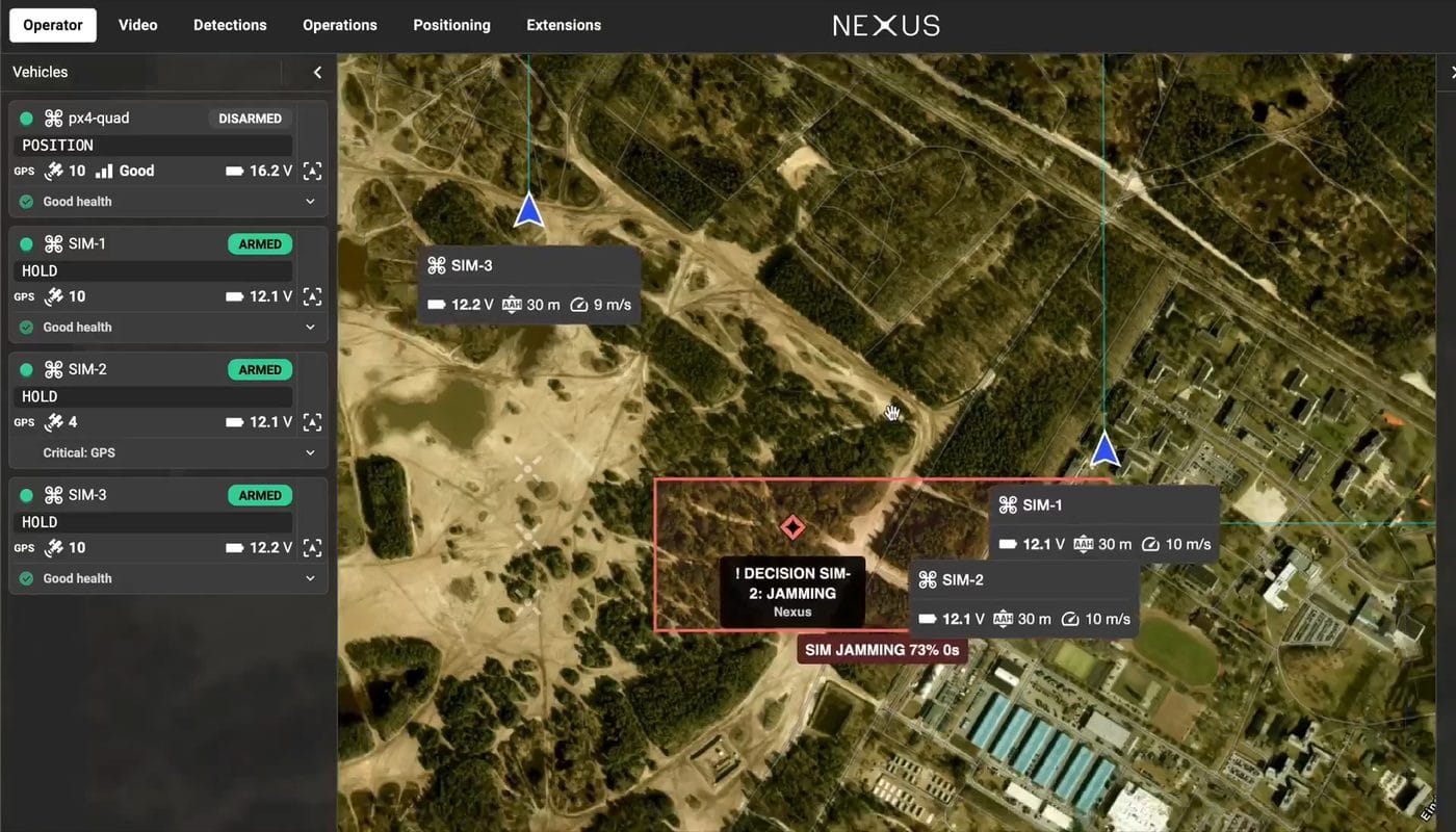
A real extension running in Nexus. I packaged the engine as a Nexus extension (Linux x64, built with PyInstaller in a Docker container). It reads fleet telemetry from the Hub API, publishes zones to the map as C2 items through the C4I API, puts a decision pin on the map for each vehicle that entered a confirmed zone, and has a page with the explanation and the decision buttons. The map could not show confidence or effect type, so I wrote the confidence into the callsign and remark text.
An interactive prototype of the wanted behaviour. The prototype shows what I wanted Nexus to offer.
Features
Five features of the extension as they look in Nexus 1.8.x with simulated vehicles, taken from the demo run.
1. Zones on the map, live in Nexus
Three real MAVLink vehicles, one jammer and one spoofer. SIM-1 to SIM-3 are real Nexus vehicles fed by ArduPilot SITL over a relay through the extension. In the demo run both zones were confirmed (jamming 56%, spoofing 65%) and drawn on the Nexus map with their age. In this run: 0 false positives, 0 missed zones.
2. Zone table
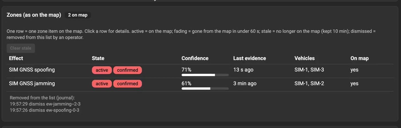
Every zone in one list, with its state (active, fading or stale), confidence, last evidence and the vehicles involved. One row is one zone drawn on the Nexus map. Stale zones can be cleared.
3. Zone details
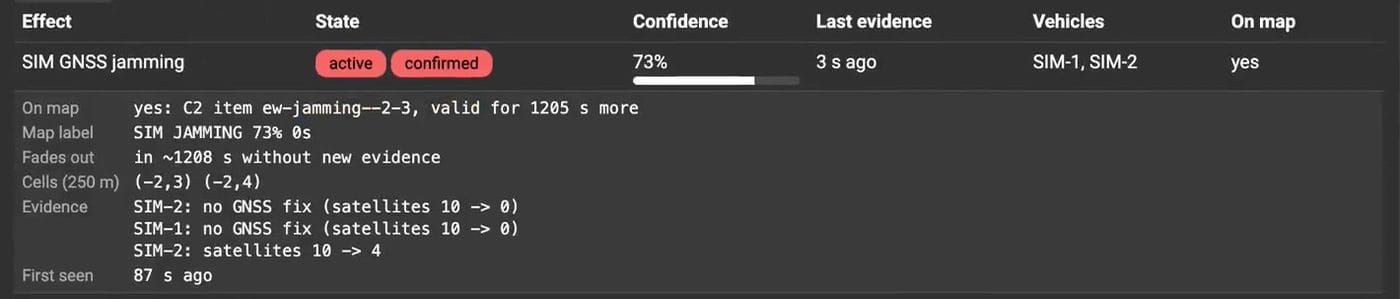
Click a row to see the evidence behind the zone: which vehicle saw what (for example satellites 10 to 0), the 250 m cells, when it was first seen, and when it fades without new evidence. The operator can check why a zone exists before acting on it.
4. Decision cards
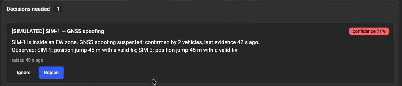
The extension interrupts the operator only when a decision is needed. Weak zones stay on the map and stay silent. For a confirmed zone, each vehicle inside it gets one card that says what was observed and by how many vehicles. Replan records the decision. The extension never sends commands to a vehicle.
5. Fading zones
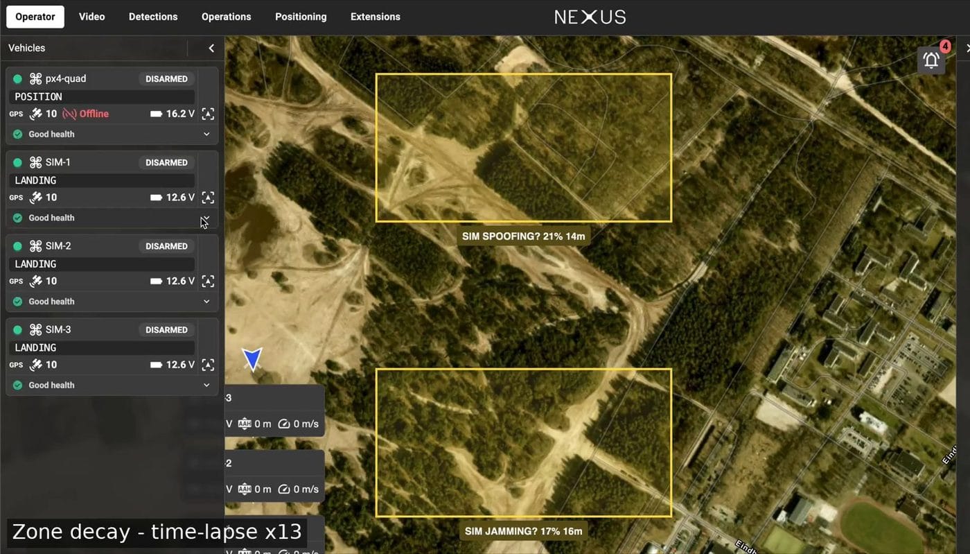
Zones nobody revisits fade instead of lying. Because the situation in a combat zone changes quickly, earlier active zones degrade and fade fast when there is no new evidence.
Result
- Won the Intelic Award at the European Defense Tech Hackathon (Almere, 13-15 November 2026), Challenge 01.
- A working extension, final version 0.4.9, uploaded to Nexus 1.8.x on 16 November. Verified in ArduPilot SITL with three simulated copters connected to Nexus as vehicles and an interference injector I wrote.
- Four ranked feedback points for the platform vendor, from info windows on the main map screen (very high impact) to a sandbox vehicle with realistic telemetry (medium).
Demo
Interactive prototype: nexus-prototype.velychko.dev (simulated data, mock-up of intended Nexus behaviour)
Honest limits
- Simulation only. The engine was verified in ArduPilot SITL with an injector I wrote. Nothing was tested on a real vehicle and I have no results on real EW data, so the accurate wording is "validated in simulation".
- Parameters are starting values. Cell size, weight cap, threshold and half-life have not been tuned on real data.
- One person, three days. No independent review, no hardware-in-the-loop. The platform feedback comes from one project in one environment and is input, not a final ranking.
- Spoofing detection has a known blind spot. It relies on the vehicle's EKF disagreeing with raw GNSS. A well-made spoof that drifts slowly and is accepted by the EKF would not be caught by this rule alone.
Next steps
- Validate on real data: recorded flight logs from jammed areas or a public dataset.
- Tune the parameters against that data and report false-positive and missed-zone rates.
- Distinguish jamming from spoofing with a lightweight model that feeds the same confidence layer.
- Work with the platform vendor on the SDK gaps (map interaction) found during the build.